My girlfriend Kimberley (with a blue jacket in the photos) and I were in Nepal in April 2013, primarily to do a 12-day hike with a group of friends from Lukla to Mount Gokyo, elevation about 5,000 meters, and back.
We flew from Kathmandu to Lukla on 04/16 in Tara Air’s Dornier 228 9N-AHS, and from there we began our hike.
Lukla Tenzing-Hillary Airport (LUA/VNLK) is located at an elevation of 2,843 m (9,328 ft) and is often referred to as “the most dangerous airport” in the world.

It is the starting point for all those who want to hike to the Everest Base Camp, about 5-6 days away, and for a number of other hiking destinations as well.
It is also in a very scenic setting with numerous snowcapped mountains surrounding it.
Landing in less than 550 m
The airport has a single runway, 06/24, which is 527 m (1,729 ft) long and has a gradient of 11.7%.

Runway “06” is at the lower end and right next to a deep ravine and “24” at the upper end has a mountain side right next to it.
For obvious reasons all landings are uphill on Runway 06.
At the very upper end of the runway the small ramp area is on the right.

Accordingly, all take-offs are downhill on Runway 24 and once you reach the end of the runway, you will be airborne no matter what.
Because of its various limitations, all flights are operated by smaller commuter aircraft, such as Twin Otters, Dornier 228s and LET 410s.
Furthermore, because of weather conditions (changing wind directions), all arrivals and departures are scheduled for early morning and there are generally no flights after 09:00 hs.

A Dornier 228, 9N-AHB, had a landing accident on 10/12/2010 when its brakes failed, and its nose was severely damaged.
It was still parked at the ramp in April 2013 on our visit, taking up one of four valuable parking spaces.
Because of the limited time in the morning that is available for flights, the activity during those two hours is frantic.

Aircraft typically leave one engine running while passengers disembark and embark and turn-arounds are often accomplished in five minutes or so.
30’ over the Himalayas
The flight between Kathmandu and Lukla takes right around 30 minutes, and the ten minutes or so before touching down at Lukla, or after departing, are very scenic, with mountains on both sides.
Only pilots who have completed ten flights into Lukla with a certified instructor pilot are allowed to land at the airport.

One aspect that I really liked was the “open cockpit door policy”, which is so unusual these days.
On both flights I was seated right behind the cockpit and the door was open the entire time on both flights, giving me the unique opportunity of looking straight out the cockpit window.
Especially on the approach and landing at Lukla this was quite exciting.

After our exciting and highly scenic 12-day hike, where we could see Mount Everest on numerous occasions, we left Lukla on 04/28, with our group checking in around 06:00 hs.
“Check-in” in the cramped and very basic terminal is a seemingly disorganized affair with numerous groups attempting to accomplish this at the same time.
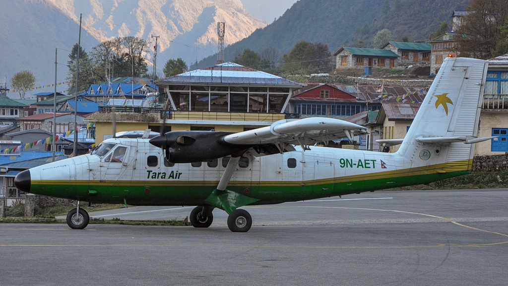
Despite the general confusion, we boarded Tara Air’s Twin Otter 9N-AET as planned, and we rolled down the steep runway by 07:00 hs. and took off without incident for the scenic but otherwise uneventful half hour flight back to Kathmandu.
About the author

Born in Sweden in 1944, Bo-Göran Lundkvist has been an aviation professional since age 16, when he began working for Transair Sweden at Malmö Bulltofta Airport on 1 June 1960, in charge of Statistics.
Following his interests in both disciplines (stats and aviation), he eventually became a worldwide commercial aircraft fleets expert, and he is best known as the former publisher of the iconic monthly newsletter, Aviation Letter, published continuously for 52 years.
Even though he hasn’t yet retired from his aircraft fleets business, he keeps himself more than fit physically and travels on a frequent and systematic way around the entire world.
Acknowledgments: Lucila Runnacles was instrumental in launching this story. Other references: Aviation Safety Network.

